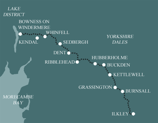
Dales Way
Ilkley to Bowness in 8 Days Walking Code: DW9
Follow riverside paths, rolling pastures, and classic Dales scenery on this rewarding walk through the heart of Yorkshire. From the historic spa town of Ilkley, the route meanders alongside the River Wharfe, passing charming villages and lush meadows with ancient dry-stone walls. As you enter Cumbria, take in the tranquil beauty of the Howgill Fells before finishing on the shores of Lake Windermere, England’s largest lake, framed by a stunning mountain backdrop. Choose from 3 itineraries.
This is the longest of our Dales Way itineraries, taking 8 days to walk the trail from Ilkley to Bowness on Windermere. Extra time is spent in Wharfedale, where the days are kept particularly short to give you plenty of time to look around the sights such as Bolton Abbey and the Strid, as well as to explore the villages, churches, inns and cafes along the way.
| Miles | Km | ||
|---|---|---|---|
| Day 1 | Travel to Ilkley for your first nights accommodation | ||
| Day 2 | Ilkley to Bolton Abbey then transfer to Burnsall | 6 | 10 |
| Day 3 | Transfer back to Bolton Abbey then walk to Grassington | 11 | 18 |
| Day 4 | Grassington to Hubberholme | 12 | 19 |
| Day 5 | Hubberholme to Ribblehead | 12 | 19 |
| Day 6 | Ribblehead to Dent | 10 | 16 |
| Day 7 | Dent to Howgill | 10 | 16 |
| Day 8 | Howgill to Burneside then transfer to Kendal | 11 | 18 |
| Day 9 | Transfer back to Burneside then walk to Bowness on Windermere | 10 | 16 |
| Day 10 | Depart from Bowness on Windermere after breakfast |
Ilkley to Burnsall
The route starts at Ilkley, an old market town marking the eastern edge of the Dales and heads upstream along the banks of the River Wharfe. Enroute you pass Addingham and Bolton Abbey, an impressive 12th century ruin set in the parkland of the Duke of Devonshire’s estate. The path enters Strid Wood, where the River Wharfe is forced through a narrow chasm and can be particularly spectacular after rain. More riverside walking leads to Appletreewick, the first in a string of delightful limestone villages, and on to Burnsall which is idyllically situated on a large meander in the river.
Burnsall to Beckermonds
From Burnsall the route carries on along the Wharfedale valley and enters the small market town of Grassington, the last town before Sedbergh, on the eastern fringes of the National Park. After Grassington the route leaves the valley for a few miles and climbs up to a plateau of limestone pavement. Here, millions of years of rainwater have dissolved deep crevices in the limestone, splitting the surface spectacularly.
The Wharfe is rejoined at Kettlewell, one of the honey pot villages of the Dales and the path follows the river gently upstream past the villages of Starbotton, Buckden and Hubberholme. This is where Wharfedale officially finishes and the route continues along the beck side up the narrow vale to Beckermonds.
Beckermonds to Sedbergh
The character of the route changes markedly here as the path climbs out of the cosy confines of Wharfedale over the wild moorland of Cam Fell. An altitude of 450m is reached at Cam Houses giving dramatic views of the Yorkshire Three Peaks, before the route descends towards Ribblehead and its famous viaduct. Moor fell sides soon lead to the gentler countryside of the River Dee and Dentdale. Riverside paths meander downstream to the village of Dent, with its narrow cobbled streets and on to Sedbergh, a small market town nestling under the steep Howgill fells.
Sedbergh to Bowness on Windermere
After Sedbergh, the walk skirts under the Howgills and along the River Lune for a few miles, where the character of the route changes again. The riversides of the Dales are left behind, as the route passes through the rolling countryside separating the National Parks of the Yorkshire Dales and the Lake District. Views of distant Lakeland mountains become more impressive as Windermere is approached.
Easy to Moderate
The route, which is waymarked over its entire length, is relatively straightforward. The paths usually follow valley systems but rises up to 450 metres at its highest point. A good route for regular walkers.
Terrain: The route generally follows rivers and valley bottoms. Crossing from Wharfedale to Dentdale (after Buckden & Hubberholme) the route rises over the moorland, up to a height of 450m.
What’s it like underfoot? On the whole the paths are well defined and maintained, but at times it can be rough underfoot with some muddy paths, so good footwear is essential.
How much up & down? Most days are rolling with gentle ascent and descents. The climb from Buckden to the high point on the route is the biggest at about 150m.
Signposting: Generally good, but use your map and guidebook as well.
Navigation: Pretty straightforward. You may encounter hill fog on the highest day, but route is pretty well defined.
Weather: You may be lucky enough to encounter warm, dry weather over the whole route and enjoy dry paths and tremendous views, but you must be prepared because the weather can change quickly. Good clothing and waterproofs essential!
|
All Holidays
|
|
| Accommodation | Overnight Bed and Breakfast accommodation in selected hotels, farmhouses, village inns, guest houses and family B&Bs. Full English or Continental breakfast. |
| Guidebook | A detailed guidebook with route information, maps, photos and background information. |
| Information of Services Along the Route | A comprehensive Service Info sheet, including services such as cash points, banks, post offices, village shops, inns, cafes and taxis. |
| Maps | A waterproof (1:40,000) Harvey Map covering the whole route. |
| Personal Itinerary | A personal itinerary setting out each overnight stop, including large scale maps of each accommodation, to ensure you find it easily. |
| Emergency Telephone Support | If you get in to difficulties during your holiday, we are always available to help, even out of office hours. |
|
Options
|
|
| Luggage Transport | We will transfer your luggage between each overnight stop – if you leave your luggage at the accommodation when you set off in the morning, it will be moved on to your next B&B. You only need to carry a small day sack with the clothes and provisions you require during the day’s walk. |
| Packed Lunches |
Provided for each day’s walking and recommended on this holiday as there will not always be a handy shop or cafe on the route. |
| Off Road Parking | If you are travelling by car we can usually arrange off road parking for the duration of your trip. (There may be a small charge for this). |
| Arrangement of return transport | We can also arrange your transfer back to your car, (or advise you when public transport is a better option)! |
|
What’s not Included
|
|
| Evening Meals | Your evening meal isn’t included in the package, but we include full details and recommendations for each evening meal in your itinerary. You will normally be within walking distance of a pub and/or restaurant, or where there is good food available at the accommodation, we’ll book that for you. Allow about £30.00 per night. |
| Transport to the Start & Away from the Finish | Have a look at the ‘Travel Info’ tab above for suggestions. If you’re still struggling, get in touch and we’ll help you sort it out. |
| Travel Insurance | Even if you are based in the UK travel insurance is worth having. |
Good accommodation and friendly hosts are an essential part of any holiday. We understand this and go out of our way to find the best. We put a great deal of effort into hand picking our accommodation and matching it to individual customer requirements. As well as visiting the accommodation ourselves, we ask all our customers to complete a short evaluation on each night’s accommodation, which then gives us an insight into the day-to-day operation and lets us spot any potential issues before they become a problem.
We use a variety of accommodation. Over the course of your trip you might stay in a village inn, a bed and breakfast in a converted barn, a Victorian guest house, or on a working farm. In selecting the accommodation we look for helpful, friendly hosts with good quality, characterful accommodation close to the trail. Occasionally we may use a chain hotel.
We always try to arrange en suite accommodation, i.e. rooms with their own bathrooms for each night of your stay. However, in some of the more remote locations accommodation is limited and occasionally we may have to book rooms with shared bathrooms for one or two nights of your holiday, (especially if the booking is made at short notice), but we will always let you know if this is likely to be the case.
We are happy to book single rooms on our holidays but cannot normally book more than two for any one group. Single room bookings include a supplement.
Here are some examples of the accommodation we use on the Dales Way:
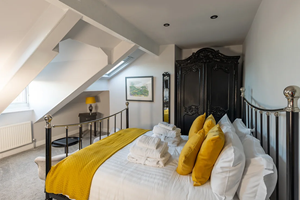 Located in the heart of Ilkley, One Tivoli Place is an award-winning, fully licensed gastro-guest house. Hosts Peter and Rika provide a warm welcome, offering comfortable ensuite rooms and an exceptional dining experience. Guests can savor authentic Japanese dishes alongside the best of British and European cuisine in the inviting dining room. Visit their website
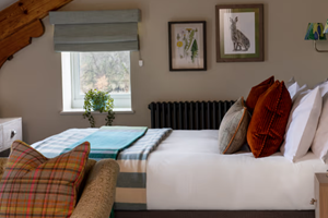 Situated in the picturesque village of Burnsall, overlooking the scenic Wharfdale, The Red Lion offers an ideal base for exploring the Yorkshire Dales and its charming surroundings. Guests can enjoy a variety of room types, a welcoming bar serving award-winning ales, and a restaurant celebrating the best of local produce. Visit their website
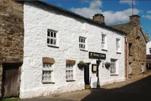 Stone Close Tea Room and B&B sits in the heart of the charming village of Dent within the Yorkshire Dales National Park. This Grade II listed 17th-century property retains its original features, exuding historical charm. Hosts Alison and Andy, with their daughter Anna, provide a warm welcome, delicious homemade cakes, and freshly prepared meals. Visit their website
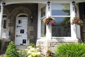 Richard and Wendy ensure a warm welcome at Hillside Bed and Breakfast. Nestled in Kendal’s conservation area, Hillside enjoys an elevated position just a short walk from the historic market town centre. With six traditional ensuite rooms, it’s a perfect base for exploring the ‘auld grey town’ and the stunning Lake District and Yorkshire Dales. Visit their website
General travel information on the Dales Way area will be in your holiday pack including train and bus timetables where available.
Detailed instructions on getting to your first night’s accommodation by car, or on foot from the nearest train or bus station, will also be included in the holiday pack on individual accommodation maps.
To view train times please visit trainline where you can also purchase tickets in advance. For information on bus timetables please visit traveline
If you require secure car parking whilst walking this route, please contact us for detailed information – we can usually arrange car parking in Ilkley and you can return to your car by public transport or taxi transfer.
Getting There:
By Air: The nearest airports are Manchester International (MAN) and Leeds Bradford (LBA). There are frequent buses or trains from the airports to Ilkley (Manchester to Ilkley is 53 miles, and Leeds to Ilkley is 17 miles).
By Public Transport: The nearest main railway station is Leeds, where there are rail connections to Ilkley.
By Road: Ilkley is situated in the Yorkshire Dales. The nearest city is Leeds (17 miles).
Returning from Bowness on Windermere:
By Air: There is a railway station in Windermere, where you can catch trains to airports: Manchester (approx 2 hours) and Leeds (approx 3 hours).
By Public Transport: There is a train station in Windermere for travel to Oxenholme on the west coast mainline. You can also travel by bus on the National Express coach service.
Bowness on Windermere
The linked towns of Windermere and Bowness at the heart of the Lake District have been an attraction for visitors since Victorian times. With the lake shore of Windermere so close, there is always something to do whatever the season - walking along the lakeside, enjoying panoramic views of the lake and mountains from several viewpoints, experiencing a whole host of water-based activities, luxuriating in the pleasures of travelling around the area by steamer, open-top bus or steam locomotive or discovering the lake for yourself by hiring a rowing boat, dinghy or cruiser. Away from the lake shore is a varied choice of heritage sites, historic houses, colourful gardens and other visitor attractions.
| Prices | USD ($) |
|---|---|
| Accommodation, map & guidebook only | $1417 |
| with Luggage Transport | $1562 |
| with Packed Lunches | $1536 |
| with Luggage & Lunches | $1674 |
Other Options |
|
| Extra Nights (per night) | $123 |
| Single Supplement (per night) | $81 |
| Solo Luggage Supplement (per day) | $0 |
