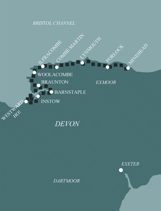
North Devon Coast Path: Minehead to Westward Ho!
Minehead to Westward Ho! in 8 Days Walking Code: DN9
We offer 3 itineraries from Minehead to Westward Ho! This quieter, more remote section of the South West Coast Path passes through Exmoor National Park, where high cliffs, sandy beaches, and ancient coastal woodland create a truly varied and scenic journey.
This 8 day option offers a couple of easier days in the middle by splitting the 14 mile stretch from Combe Martin to Woolacome over 2 shorter days – a welcome break before further lengthy days.
| Miles | Km | ||
|---|---|---|---|
| Day 1 | Travel to Minehead for your first nights accommodation | ||
| Day 2 | Minehead to Porlock | 7 | 11 |
| Day 3 | Porlock to Lynmouth | 14 | 23 |
| Day 4 | Lynmouth to Combe Martin | 14 | 23 |
| Day 5 | Combe Martin to Ilfracombe | 5 | 8 |
| Day 6 | Ilfracombe to Woolacombe | 9 | 14 |
| Day 7 | Woolacombe to Braunton | 15 | 24 |
| Day 8 | Braunton to Instow | 13 | 21 |
| Day 9 | Instow to Westward Ho! then transfer to Appledore | 11 | 18 |
| Day 10 | Depart from Appledore after breakfast |
Minehead to Porlock Weir
The South West Coast Path begins in Minehead, actually in Somerset rather than Devon. To mark the start of the full 630 miles there is a wonderful sculpture of two hands opening a map of the route. Have your photo taken to mark the start of your adventure! Minehead is a lively town with lots of museums and good public transport links.
The trail eases you in as you leave the town behind you and follow the path through woodland, along steep cliff tops through beautiful wooded combes with bracken and gorse. After a few miles you emerge from the woodland at North Hill where you have two options of the route to choose from. The low route is a gentle walk through farmlands passing by field of livestock. The more rugged alternative route offers a wilder, longer and more remote experience with better sea views where you might be able to spot some of the local wildlife.
On a clear day this section has fantastic views across the Bristol Channel to the Welsh Coast and tiny islands of Steep Holm and Flat Holm. The two paths meet up at Bossington from where you follow a flat track to the village of Porlock Weir which is home to a thousand year old port and several thatched cottages.
Porlock Weir to Lynmouth
From Porlock Weir you leave the harbour and houses at Millers and Anchor, climbing the steep slopes passing thatched houses. One essential stop on the South West Coast Path is at Culbone Church of St Beuno which is apparently the smallest parish church in England at only 35ft long with enough room to fit 30 people. From this church you have two options of the trail to choose from.
The southern trail from here heads up the hill, out of the trees, into farmland and from there onto a quiet road. The northern trail is through ancient woods and is known to be rugged but it is rich in history and a wonderful alternative to the southern trail.
Once back on the main route you then follow the coastline under the woodland canopy climbing the slopes onto the clifftops. Here you will cross the Somerset-Devon border. The path then deviates off the main track to allow you to visit the 19th Century stone cross known as Sister’s Fountain.
From here the trail becomes more exposed which is a pleasant change from walking through the woodlands. From Coddow Combe you then reach Foreland Point which is the most northerly point in Devon with beautiful view of Lynmouth in the near distance.
Lynmouth to Combe Martin
From here your walk connects with another trail called the Tarka trail which is named after Henry Williamson’s book ‘Tarka the Otter’. There are several locations along this part of the trail that Williamson based his book on and it is interesting to spot these whilst on your walk.
You will start the day along an easy tarmac path then a grassy path skirting Hollerday Hill. There are stunning views out to sea and along the shoreline to the spectacular rock formations of Valley of Rocks with the appropriately named Castle Rock ahead of you.
From here there’s a short but pleasant road walk with Lee Abbey on your right which was built in 1850. You then continue up a steep and wooded road route, or you can choose a more off-piste Woody Bay alternative route around Crock Point.
On this section you can enjoy the many cliff top flowers, especially the abundance of bluebells and primroses in the springtime. The Exmoor coasts provides a wide and interesting habitat for many rare species of flora and fauna, which include red deer, stag beetles, blackneck moth and the whitebeam trees which are unique to Exmoor.
Soon you will reach the highest point on the South West Coast path at Great Hangman standing at 1043 feet and rewarding you with breath-taking views here of Exmoor, the Welsh coast and Lundy. Please note this is a challenging walk, particularly the steep climb up Great Hangman from Sherrycombe as you are exposed to the elements. It is only a short distance from here to Combe Martin where you can rest your feet after your challenging days walk.
Combe Martin to Woolacombe
With stunning coastal views, this section from Combe Martin is well known for its wild and spectacular views. There are some easy cliff paths but also a few strenuous ascents between Lee Bay and Morte Point. Morte Point is designated a Site of Special Scientific Interest for its heathland and grasses. You might be able to spot grey seals, gannets and in the summertime dolphins, sunfish and even basking sharks. After Morte Point the vast sandy bay of Woolacombe will come into view.
Woolacombe to Braunton
From Woolacombe the trail is a lot flatter which allows you to take in the view a bit more and you’ll notice the change in scenery. From Baggy Point you can spot lots of seabirds and even the odd rock climber. The views change from the cliff tops and woodland paths to a much flatter and easier path closer to the shoreline.
The route then passes through the village of Croyde and Saunton which are both known as a haven for surfers. You will also pass through Saunton Sands which is an army training location and access can be limited. Although, you are well compensated as the dunes at the back of Saunton form the Braunton Burrows which is an area of Outstanding Natural Beauty. Braunton Burrows Nature Reserve, has the largest sand dune system in England and is home to rare snails and lizards.
Braunton to Instow
From Braunton the trail follows the estuary on the disused railway track and you need to keep a close eye on the directions in your guidebook to avoid taking a wrong turn onto a paved path near a busy road. The trail continues on through the Burrows along the banks of the Taw River, where you might spot the odd heron, oystercatcher and even an egret or godwits. This section of the SWCP keeps in-line with the Tarka Trail with views of the marshes across the estuary.
Instow to Westward Ho!
The Tarka trail diverts away from you now on the last stage. The trail from Instow is mainly on paved pathways and is fairly flat walking. You are treated to views back over the river Taw as you follow the Torridge River south towards Bideford. Cross the bridge then again follow the river north sticking to the paved path which is well signposted. Soon you will reach the village of Appledore and, shortly after that, Northam Burrows Country Park which is filled with grassy plane landscapes and marshes that are a brilliant spot for birdwatching. The route then hugs the side of Pebble Ridge which is a hot spot for surfers and you can stroll along the beachfront to your final evening at Westward Ho!
Moderate
Grades - This is not a technically difficult walk and should be easy to tackle for most reasonably fit people.
Terrain - The paths are good, and there are no major route finding challenges.
What’s it like underfoot? Generally good paths and tracks, although a few sections can get muddy after heavy rain.
How much up & down? – More than you’d think! Although you never reach more than 400m above sea level (and most of the time not more than 200m) there are many short steep sections. Most days involve ascents of 200-400m metres, although no section is very steep for very long.
Signposting: Good – the path is well waymarked.
Navigation: Pretty straightforward – good signposting, and generally well defined tracks.
Weather: You may be lucky enough to encounter warm, dry weather over the whole route and enjoy dry paths and tremendous views, but you must be prepared because the weather can change quickly. Good clothing and waterproofs are essential, but don’t forget you sunhat, sunblock and shorts!
|
All Holidays
|
|
| Accommodation | Overnight Bed and Breakfast accommodation in selected hotels, farmhouses, village inns, guest houses and family B&Bs. Full English or Continental breakfast. |
| Guidebook | A detailed guidebook with route information, maps, photos and background information. |
| Information of Services Along the Route | A comprehensive Service Info sheet, including services such as cash points, banks, post offices, village shops, inns, cafes and taxis. |
| Maps | A waterproof (1:40,000) Harvey Map covering the route. |
| Personal Itinerary | A personal itinerary setting out each overnight stop, including large scale maps of each accommodation, to ensure you find it easily. |
| Emergency Telephone Support | If you get in to difficulties during your holiday, we are always available to help, even out of office hours. |
|
Options
|
|
| Luggage Transport | We will transfer your luggage between each overnight stop – if you leave your luggage at the accommodation when you set off in the morning, it will be moved on to your next B&B. You only need to carry a small day sack with the clothes and provisions you require during the day’s walk. |
| Packed Lunches |
We are unable to pre book packed lunches on this route. However, some accommodations will be happy to prepare a packed lunch if requested on arrival. |
| Off Road Parking | If you are travelling by car we can usually arrange off road parking for the duration of your trip. (There may be a small charge for this). |
| Arrangement of return transport | We can also arrange your transfer back to your car, (or advise you when public transport is a better option)! |
|
What’s not Included
|
|
| Evening Meals | Your evening meal isn’t included in the package, but we include full details and recommendations for each evening meal in your itinerary. You will normally be within walking distance of a pub and/or restaurant, or where there is good food available at the accommodation, we’ll book that for you. Allow about £30.00 per night. |
| Transport to the Start & Away from the Finish | Have a look at the ‘Travel Info’ tab above for suggestions. If you’re still struggling, get in touch and we’ll help you sort it out. |
| Travel Insurance | Even if you are based in the UK travel insurance is worth having. |
Good accommodation and friendly hosts are an essential part of any holiday. We understand this and go out of our way to find the best. We put a great deal of effort into hand picking our accommodation and matching it to individual customer requirements. As well as visiting the accommodation ourselves, we ask all our customers to complete a short evaluation on each night’s accommodation, which then gives us an insight into the day-to-day operation and lets us spot any potential issues before they become a problem.
We use a variety of accommodation. Over the course of your trip you might stay in a village inn, a bed and breakfast in a converted barn, a Victorian guest house, or on a working farm. In selecting the accommodation we look for helpful, friendly hosts with good quality, characterful accommodation close to the trail. Occasionally we may use a chain hotel.
We always try to arrange en suite accommodation, i.e. rooms with their own bathrooms for each night of your stay. However, in some of the more remote locations accommodation is limited and occasionally we may have to book rooms with shared bathrooms for one or two nights of your holiday, (especially if the booking is made at short notice), but we will always let you know if this is likely to be the case.
We are happy to book single rooms on our holidays but cannot normally book more than two for any one group. Single room bookings include a supplement.
Here are some examples of the accommodation we use on the North Devon Coast:
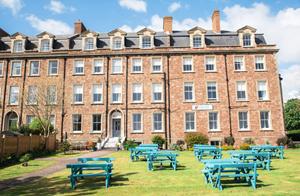 Foxes Hotel, nestled on Minehead’s picturesque seafront offers a unique and welcoming stay. This charming Victorian seaside hotel is also a fully operating training hotel for young people with learning disabilities. Guests can enjoy breathtaking views and a warm atmosphere dedicated to creating lasting memories. Visit their website
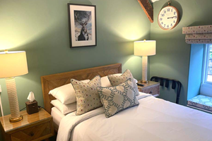 Myrtle Cottage, a 400-year-old thatched cottage in Porlock, exudes charm and character. Perfectly placed within Exmoor National Park, it is surrounded by breathtaking scenery and it’s just a short stroll from the sea, plus easy access to local pubs and restaurants. Guests enjoy beamed bedrooms with modern en suites. Visit their website
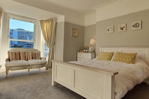 At Rocky Cove B&B in the heart of Ilfracombe, hosts Nicki and Jonah offer a warm and welcoming stay. Passionate about the area they fell for in love with, they ensure guests enjoy cosy accommodation and a connection with the sea. Just minutes from the harbour, shops and restaurants, it’s ideal for exploring North Devon. Visit their website
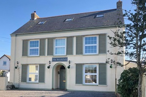 Victoria and Chris extend a warm welcome to The Brookfield, a charming Georgian property in Braunton. Built in 1798, this boutique-inspired B&B blends contemporary style with original Georgian features. Nestled on South Street, it offers a peaceful retreat just 400 meters from the village’s shops, pubs and eateries. Visit their website
General Travel information for the South West Coastal Path will be in your holiday pack including train and bus timetables where available.
Detailed instructions on getting to your first night’s accommodation by car, or on foot from the nearest train or bus station, will also be included in the holiday pack on individual accommodation maps.
To view train times please visit trainline where you can also purchase tickets in advance. For information on bus timetables please visit traveline
If you require secure car parking whilst walking this route, please contact us for information.
Getting to Minehead:
By Air: If travelling from overseas the main airport to fly to is London Heathrow. From London Heathrow you can travel by train from London Paddington Station to Taunton station, you then take the bus (No. 28) from Taunton to Minehead (journey time approx. 4 hours). Alternatively you may wish to travel via Bristol Airport. From Bristol Airport you take the bus to Temple Meads train station, the train to Taunton, and bus (No. 28) onward to Minehead (journey time approx. 3 hours)
By Public Transport: The nearest mainline railway station to Minehead is at Taunton. You can travel to Taunton from London Paddington by train and then from Taunton to Minehead by bus (No. 28) (journey time approx. 4 hours).
By Road: Minehead is located just off the A39. Leave the M5 motorway at Junction 23 and follow the A38/A39 towards Bridgewater/Minehead. Stay on the A39 for approx. 25 miles. The town centre and seafront are signed from the A39.
Returning from Appledore:
By Public Transport: The nearest railway station to Appledore is Barnstaple. Stagecoach South West bus service 21 runs between Appledore and Barnstaple Railway Station half hourly (hourly on Sundays), journey time approx. 50 minutes.
By Road: From Appledore, follow the A386 towards the A39. When the road meets the A39 follow signs for Barnstaple, after approx. 9 miles the A39 meets the A361 at a roundabout. Follow the A361 for approx. 35 miles passing Barnstaple and Tiverton to join the M5 at junction 27.
Lynmouth
Spend a day exploring the picturesque twin villages of Lynton and Lynmouth, dubbed “England’s Little Switzerland” ever since Robert Southey remarked upon their distinctly Alpine appearance. Ride the Cliff Railway funicular which connects Lynmouth at the foot of the cliffs to Lynton, perched 500 feet above. Visit Watersmeet and indulge in a cream tea (and argue about where the jam goes) in the tea garden before exploring the ancient woodlands in and around one of the country’s deepest river gorges. There are plenty of historic houses and gardens nearby, or just spend a day experiencing the local arts and crafts and a spot of shopping.
Ilfracombe
With a growing reputation as North Devon’s culinary and cultural hub, Ilfracombe is built around a small working harbour and offers fresh seafood brought in daily and a thriving local arts and crafts scene. Don’t miss the divisive ‘Verity’ – Damien Hirst’s 20 metre bronze statue representing truth and justice – or the Tunnels Beaches, reached through tunnels hand carved in the 1820s, which helped turn the village into a popular seaside hotspot. Take a ferry to Lundy Island, fantastically diverse for an island only three miles long and half a mile wide. Or if you prefer to keep your feet on dry land try an evening stroll to Capstone Hill for panoramic views across the town and watch the sun set into the Atlantic.
| Prices | AUD ($) |
|---|---|
| Accommodation, map & guidebook only | $2280 |
| with Luggage Transport | $2572 |
Other Options |
|
| Extra Nights (per night) | $198 |
| Single Supplement (per night) | $135 |
| Solo Luggage Supplement (per day) | $35 |